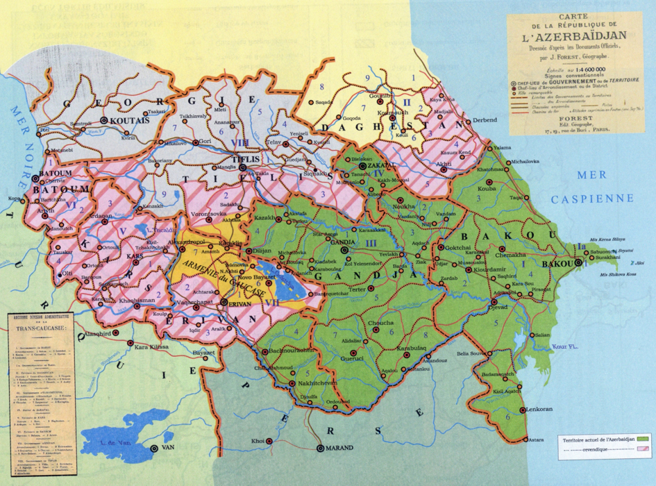
Territory
The territory of Azerbaijan in the time of the Azerbaijan Democratic Republic was as follows: Baku province (Baku district together with the Baku circle, Javad district, Goychay district, Shamakhi district,

Quba district, Lankaran district); Yelizavetpol (Ganja) province (Yelizavetpol i.e. Ganja district, Javanshir district, Nukha district, Arash district, Shusha district, Garyagin i. e. Jabrayil district, Zangazur district, Gazakh district (one-third of these territories which consisted of mountainous areas, were disputed between Azerbaijan and Armenia); Irevan province (Nakhchivan district, Sharur-Daralayaz district, as well as, a part of New Bayazid, Echmiadzin and Surmeli districts), Tbilisi province (a part of Borchali, Tbilisi and Signakh districts), Zagatala circle.
As soon as the military forces of Ottoman Empire defeated in the First World War, withdrew from the South Caucasus, the Armenians asserting its territorial claims occupied Lorin in Borchali district and its circles as a result of the war with Georgia at the end of 1918. Armenia expanded genocide acts in Karabakh, Zangazur, Nakhchivan and other regions in order to carry out its territorial claims against the historical lands of Azerbaijan. With a view to avoid this policy, Araz Turk Republic was established in Nakhchivan in November, 1918 and then it was united to the South-West Caucasus Democratic Republic founded in Kars. In spite of an extremely complicated international and domestic situation, territorial and border issues were of vital importance for the Azerbaijan Democratic Republic. Government of the Azerbaijan Democratic Republic was trying to keep the entire historical lands of Azerbaijan in the South Caucasus under control. The table depicting the territory of the Azerbaijan Democratic Republic was published in the address-calendar of 1920 on the basis of the map and information presented by the Ministry of Foreign Affairs.
The territory of the Azerbaijan Democratic Republic (by square verst and square kilometer)
| Territory |
sq. verst |
sq. kilometre |
Note |
|
Baku province |
34276,45 |
39075,15 |
Indisputable territory |
|
Ganja province |
38922,22 |
44371,29 |
|
|
Zagatala circle |
3502,24 |
3992,54 |
|
|
Irevan province* |
8647,99 |
9858,69 |
|
|
In all |
85348,90 |
97297,67 |
|
|
Irevan province ** |
6941,41 |
7913,17 |
Disputable territory |
|
Tiflis province *** |
7618,56 |
8685,13 |
|
|
In all |
14559,97 |
16598,30 |
|
|
Total |
99908,87 |
113895,97 |
* Indisputable territory of Irevan province includes: 1st and 2nd police areas of Sharur-Daralayaz district; 1st, 2nd, 3rd and 4th police areas of Nakhichevan district; 1st and 2nd police areas of New Bayazid district
**Disputable territory of Irevan province includes: 1st, 2nd, 3rd and 4th police areas of Irevan province; 2nd and 3rd police areas of Echmiadzin district; 1st, 2nd and 3rd police areas of Surmeli district; a part of the 3rd police area of New Bayazid district
***Disputable zone includes the following parts of Tiflis province: 2nd and 3rd police areas of Tiflis district; 5th police area of Signakh district; a part of the 1st, 2nd, 3rd and 4th police areas of Borchali district
Evidently, the territory of the Republic covered 113.9 thousand square kilometres (97.3 thousand sq. km indisputable territory and 16.6 thousand sq. km disputable territory). Within a short period of time, Azerbaijan Democratic Republic had taken effective measures in protection of its territory and borders. But, as a result of discriminatory policy pursued by Soviet Russia, after the Bolshevik takeover of ADR on April 27, 1920, the territory of Azerbaijan was significantly diminished. The territory of the newly established Azerbaijan Soviet Socialist Republic was determined 86.6 thousand square kilometres. Thus, 27.2 thousand square kilometers of the territory of Azerbaijan Democratic Republic was taken away from Azerbaijani people.
